The engagement of this project has ended
 Corby Walking & Cycling Plan
Get project news
Do you want to receive an email when news items are posted?
News on Corby Walking & Cycling Plan
Back to newsProposed Main Corridors for Corby LCWIP
 Proposed Main Corridors for Corby LCWIP
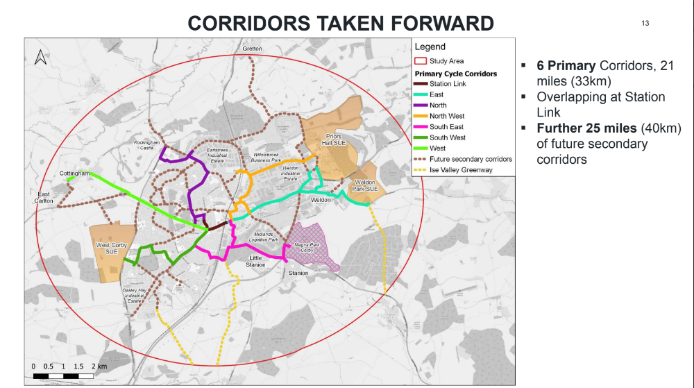
 Following the third stakeholder workshop in December 2022 along with extensive route assessments and other research by the team, a network of six primary corridors across the Corby area for improvements for walking and cycling have been proposed. These are linked across the town centre by the 'station link' route which has already undergone public consultation. Combined they total 21 miles. Anadditional 25 miles of 'secondary' routes have been added to the proposal for future potential development, for example towards Gretton which could become part of the wider North Northamptonshire Greenway.
The six main routes and the station link are shown above. More information about the proposed changes for these routes are shown below as the Overview. (See further down for full text version):
 Overview East
 Length of route: 7.3km. Connects the town and Weldon and Priors Hall (Park) and Weldon Park. 22 comments received, general consensus at the workshop. Strong local support. New links between Weldon and Priors Hall (Park) with improved A43 crossings. Potential for a fully segragated cycleway along Weldon Road and a possible new links towards Weldon Park. Junction improvements necessary.
NorthLength of route: 5.2km.Includes large residential estates, Rockingham Castle and sports pitches. A spur to industrial estate to the north and links within town centre to the south. 6 comments on Commonplace. Potentially: new traffic-free route from the cemetery, around the sports pitches to Rockingham Castle. Improved cycle route through a service road along Rockingham Road and segregated cycleway along Studfall Av.
North East(Note marked in error on original map as 'North West' but now corrected). Length of route: 5.4km.Connects the town, industrial estates and Priors Hall. Received 13 comments. Potential to improve connectivity across the railway line. Safe, fully segregated cycleways around Old Village and A6086. Improved crossings to retail park. Junction improvements along Steel Road to give priority to cyclists.
South EastLength of routes: 5.4km.Cluster of Stanion, Little Stanion and employment. New cycle link to Corby across the railway line to link residential areas and employment. Magna Park Corby site with thousands of jobs. 11 comments received. Path along Long Croft Road to be widened, shared use path along Lyveden Way to be segregated. Better signage. A43 Holiday Inn roundabout highlighted as a safety concern. Better links with Stanion.
South WestLength of route: 4.2km.Strategic link between residential estates and town cente. Includes Kingswood Academy and West Corby SUE (Sustainable Urban Extension, ie development) in the future. Highlighted 4 times at the workshop but only 3 comments on Commonplace -> currently engaged with the Kingswood community. Junction improvements along Oakley Road to give priority to cyclists and improved crossings.
WestLength of route: 5.2km.Villages to the west of Corby form a cluster. Highlighted 4 times at the workshop and 6 comments received on Commonplace. Footways along Westcott Way to be widened with new segregated cycleways. Improved crossings are necessary. Potentially reduced speed limits in the village.
Station LinkLength of route: 1km. Key central location. Joins other corridors together. High volume of movements. Improves connectivity between the town centre and the station with a scope for further improvements at both ends. Plans further than other corridors (with a separate public consultation). Proposed segregated cycleway adjacent to the northern side of Oakley Road.